Pages

October 22, 2009

The Ice are melting!!!


• Average temperatures have climbed 1.4 degrees Fahrenheit (0.8 degree Celsius) around the world since 1880, much of this in recent decades, according to NASA's Goddard Institute for Space Studies.

• The rate of warming is increasing. The 20th century's last two decades were the hottest in 400 years and possibly the warmest for several millennia, according to a number of climate studies. And the United Nations' Intergovernmental Panel on Climate Change (IPCC) reports that 11 of the past 12 years are among the dozen warmest since 1850.

• The Arctic is feeling the effects the most. Average temperatures in Alaska, western Canada, and eastern Russia have risen at twice the global average, according to the multinational Arctic Climate Impact Assessment report compiled between 2000 and 2004.

• Arctic ice is rapidly disappearing, and the region may have its first completely ice-free summer by 2040 or earlier. Polar bears and indigenous cultures are already suffering from the sea-ice loss.

• Glaciers and mountain snows are rapidly melting—for example, Montana's Glacier National Park now has only 27 glaciers, versus 150 in 1910. In the Northern Hemisphere, thaws also come a week earlier in spring and freezes begin a week later.


• Coral reefs, which are highly sensitive to small changes in water temperature, suffered the worst bleaching—or die-off in response to stress—ever recorded in 1998, with some areas seeing bleach rates of 70 percent. Experts expect these sorts of events to increase in frequency and intensity in the next 50 years as sea temperatures rise.

• An upsurge in the amount of extreme weather events, such as wildfires, heat waves, and strong tropical storms, is also attributed in part to climate change by some experts.


by the National Geographic News

October 21, 2009

what is capoeira?

Capoeira is far from one of the most popular forms of Martial Arts. But I must admit, coming from having dancing lessons as a child, I was immediately taken by the concept of this style. I had the privilege of seeing it performed live when I went to Jamaica several years ago. The images along with the music still burn in my mind.

A Brazilian style of Martial Arts, Capoeira resembles a dance as much as a form of combat. Instead of the traditional stationary starting stance most Martial Arts styles have, Capoeira begins with a Ginga, a side-to-side movement to the beat of the music. From there, the combatants move to perform a variety of attacks and evasions. Some of the movements remind me of complex break dancing routines of the 1980’s. Only, these movements carry with them deadly intent. Much of the movements focus on the feet rather than the hands, emphasizing evasion over blocking.

Coming to Brazil through Angolan slaves, the basis for this art is traditional African dances and rituals. An artisan under Capoeira should expect to not only learn the moves but the music and songs (Ladainha) of this rich art form. The music is performed on special instruments:
# Berimbau -- a musical bow with a gourd at the end
# Pandeiros -- a tambourine
# Agogo -- two iron bells
# Reco reco -- bamboo scrapper
# Atabaque -- barrel hand drum

Instructors are known as Mestre. Recent movements include some distinguishing between Angola and Regional forms of this style

by Caroline Chen

October 14, 2009

PRETORIA


Known as the Jacaranda City for all the purple blossom-bedecked trees, which line its thoroughfares, Pretoria is a lovely, quiet city. It has a long, involved and fascinating history. Here you will find significant old buildings and fascinating museums. The Transvaal Museum has natural history displays and is the home of Mrs Ples, the australopithecine fossil found at Sterkfontein in the Cradle of Humankind. Also worth visiting are the Cultural History Museum and Smuts Museum in Irene, outside Pretoria.

Sedate, leafy Pretoria tends to endure a Cinderella complex when compared with the neighbouring city of Johannesburg. When it comes to world class cities, Johannesburg is one of the most ‘happening’ cities on the African continent and the city gleams with the glamour of money. Pretoria has been left to shrug off its former association with the apartheid government in a relative state of slumber, lying as it does in a warm, sheltered valley surrounded by the hills of the Magaliesberg range that ensure that temperatures here are invariably a few degrees warmer than Johannesburg.

But don’t let the sleepy nature of the pretty city lull you into a false perception. Pretoria has a beauty all of its own, and the slow pace of life is regarded as a bonus by its residents. Many Jo’burgers seek a quieter existence in Pretoria, prepared to commute daily rather live in the comparative rat race. Wall flower the city is not. When in full bloom in October, Pretoria literally comes alive with blossoms and leaves no one in doubt as to the origin of its nickname - Jacaranda city.


Pretoria, South AfricaPretoria functions as one of three capitals of South Africa with a population that exceeds a million people, the bulk of whom are government officials. The city centre is laid out in typical city fashion on a grid with wide roads, making getting around fairly simple.

Pretoria’s potential name change to Tshwane (the city lies in the greater Metropolitan municipality of Tshwane) was approved by the names’ council in 2005 but still lacks endorsement by the Minister of Arts And Culture, remaining ‘under consideration’, which may or may not have something to do with the hue and cry that ensued at the onset of the name change. Practically mandatory when visiting the city are the Pretoria Botanical Gardens, the Zoo, the Union Buildings and various museums and galleries that include Melrose House, the Pioneer Museum, Sammy Marks museum, and the Voortrekker Monument. Outdoor activities include the Wonderboom and Groenkloof Nature Reserves, the Austin Roberts Bird Sanctuary, and a steam train ride around Pretoria.

Po River Delta


The Po, known in past times as the Eridano, is Italy's longest river. It measures 652 km in length, has an average capacity of 1,500 m3 (as measured at the height of Ferrara), and a drainage basin measuring approximately 75,000 km2. The importance of the river makes it comparable to other great European rivers such as the Rhone, the Danube, the Rhine, and the Guadalquivir. One of the main characteristics of the Po is its delta, a landscape in constant transformation due to its typical lobed shape caused by the accumulation of sediments. This large river flows through a variety of different habitats. The final stretch is typical of water courses found in flat areas: the river is shallow, the water warm and slow-flowing; vegetation is abundant; the river bed is muddy and subject to a wide range of habitats. The main indigenous fish varieties found in these habitats are: carps, rudds, bleaks, eels, roaches, nases, common barbels, and royal perches.
These waters' predator par excellence was the pike until the increasingly numerous silurus, a Central European species, found in the Po an extremely favourable environment in which to grow and reproduce. Also numerous are fish varieties introduced in the Po in ancient times, among them: the crucian (a fish highly resistant to temperature changes and to pollution), the sunfish, the largemouth bass, and the catfish (an active nocturnal riverbed predator). The Po also hosts fish that migrate seasonally to salty habitats for food, but which then return upstream for reproduction purposes.

Among these are the twaite shad (a species whose sexually mature adults migrate in the spring to reach their zone of reproduction in the middle stretch of the Po and its affluents), and the Adriatic sturgeon, which likewise migrates from the sea to the river in order to complete its reproductive cycle. The great decrease in the numbers of these two species is due to the dams that have been built along the river, which interrupt the fish's journey and therefore do not permit them to reach their reproduction zones, and to the serious environmental degradation that has taken place in the last decade. Pollution has particularly affected the population of sturgeons, a species whose morphological characteristics permit us to define it as a real living fossil.
Moreover, the progressive degradation of the Po is profoundly changing the extant relationship between the river and the human population of the surrounding areas: professional fishers are abandoning the river because they can no longer make a living from it, and even non-professional fishers are turning to drainage canals or, in some cases, to private lakes where they must pay a fee but where they have a higher chance of catching fish. Not to mention the tourists and bathers who once came numerous to the river's shores in search of respite from the sultry summer heat but whom it is increasingly difficult to spot.
This great river of ours and its amazing delta represent an immeasurably precious natural, cultural, and social heritage, a whole ecosystem to be protected and preserved. The "park", currently still under definition, is certainly a step in the right direction for the protection of this precious environment.

POPOCATEPETL MOUNTAIN


All these peaks are of volcanic origin, however, of these five peaks it is only Popocatepetl that is active and it is the volcanic activity that has brought about its climbing history. Before the arrival of the Spanish conquistadors, the Aztec emperor Moctezuma sent ten of his strongest warriors up the mountain to find the source of the smoke. Two of them died on the ascent while the rest reached the summit and saw the smoke belching from fissures within the crater. On the descent, another six perished from the cold, however, two managed to report what they had seen to Moctezuma but never recovered their pre-summit health.

The first European ascent of Popocatepetl happened in 1522 and marks the highest summit climbed by Europeans up to that time. The Spanish conqueror, Hernando Cortés, on his trek through Mexico, crossed the pass (Paseo de Cortés) between Popocatepetl and Iztaccihuatl and saw the Aztec capital of Tenochtitlán located where modern Mexico City is now situated. After his brutal conquest of the Aztecs, Cortés found himself in need of sulfur to replenish his supply of gunpowder. He dispatched a party of soldiers led by Francisco Montaño to climb Popocatepetl and obtain the material from the crater. They found the ascent trying due to the cold, temperatures they were not use too in the lower altitudes, but managed to reach the top. To acquire the sulfur, Montaño had to be lowered on a rope down the cliffs surrounding the crater. Despite his fears of falling and going straight to hell, he and his men managed to get hold of a supply of the badly needed yellow powder and return alive.

To the Aztecs, Popocatepetl is revered as one of the most important of their sacred mountains. Its rich volcanic soil combined with a congenial climate and plentiful water to make its lower slopes one of the most fertile and heavily populated areas of Pre-Columbian Mexico. The closer the maize grew to the mountain, the earlier it ripened and the better it tasted. Despite the mountains wrathful nature it represented to many Aztecs divine embodiment of all that was good and desirable.

The irony is that Cortés used a substance from the Aztec's sacred mountain to make gunpowder for killing people for the greater glory of the Spanish empire. At the same time the Aztecs performed their own bloodthirsty human sacrifices as a worship to the mountain.

In Nahuatl, the ancient language of the Aztecs, Popocatepetl means "smoking mountain" while neighbouring Iztaccihuatl means "sleeping woman." The close physical proximity of these two mountains has brought about a popular legend.

According to the widely held legend, Popocatepetl was a warrior of an Aztec tribe who fell in love with Iztaccihuatl, the daughter of the tribal chief. When the two lovers went to her father to ask to be allowed to marry, he told them he would only agree to their marriage if Popocatepetl would first conquer an enemy tribe and bring him the head of its leader. The young warrior succeeded in his mission, but he took so long that Iztaccihuatl, thinking he had perished, succumbed to sorrow. When Popocatepetl eventually returned triumphant, he found Iztaccihuatl dead, so he picked her up and carried her to the top of a mountain. He laid her along the summit ridge where she assumes the form of a sleeping woman - the shape many people see in the outline of Iztaccihuatl today. Popocatepetl lit a torch and stood watch over his lover, which accounts for the smoke that issues from the mountain that bears his name.

The ascents of Popocatepetl by Moctezuma's soldiers and Francisco Montaño were not considered, at the time, mountaineering feats, however, mountaineering as a sport took on a new meaning in the mid 1800's with the ascent of all the big peaks in the European Alps. Eventually, mountaineers began going abroad seeking new adventures. Mountaineers such as Edward Whymper, Matthias Zurbriggen and Edward Fitzgerald visited the mountains of New Zealand, Canada, South America and Mexico making their mark with first ascents of many previously unclimbed mountains. In the mid 1900's, with the convenience of cheap air travel and the advent of modern climbing techniques and equipment, contemporary mountaineers sought out the challenges of not only the lofty Himalayas, but also many exotic mountains including the Mexican volcanoes. These volcanoes have since become a popular destination, especially for North American's, seeking their first taste of high altitude mountaineering.


Technically there is nothing difficult about climbing Popocatepetl and many people have reached its summit including the Argentine revolutionary Ernesto (Che) Guevara. Guevara made an attempt in July with some of his Cuban friends but returned and summited on October 12, 1955. For Guevara, who suffered severely from asthma, the climb, which to him meant the summit, was the ultimate challenge. It was to prove his strength of mind and determination. As a revolutionary, and a climber, Guevara had the "to the summit or bust" attitude that we see in a few strong-minded Himalayan mountaineers. For them the goal must be achieved. Death is a natural consequence that they are willing to accept as we can see in Che's writing in a letter to his mother on July 20, 1955:


I took the Popo by assault, but despite much heroism, I was unable to reach the top. I was ready to die for it, but my Cuban climbing companion scared me because two of his toes froze… We spent six hours fighting the snow that buried us to our waist, and with feet totally drenched since we lacked the proper equipment. The guide got lost in the fog skirting a crevass, and we were exhausted from the soft and unending snow. The Cubans won't climb again, but for me, as soon as I have some money, I will challenge the Popo again ...

In 1988 it was my turn to make an ascent of the famous volcano. On the morning of October 19, Geoff Mahan and I left our hotel in Mexico City and took a bus to the small town of Amecameca. After picking up a few last minute supplies at the local supermarket we then arranged for a taxi to take the two of us up to the hotel at Tlamacas. Tlamacas being a popular destination not only for climbers but also for Mexican tourists to see the volcano up close and to take short hikes on the lower slopes. Once at the hotel we enquired about the condition of the huts higher up on the mountain and found there was no water available. Since we didn't have containers for carrying any extra water we decided to take a bunk in the climbers hostel adjacent to the hotel.

Although Geoff and I had spent four months climbing throughout the Andes of South America we found that in the last month of traveling in Central America we had lost much of our acclimatization. That afternoon we went for a walk up the trail to about 4,500 metres to familiarize ourselves with the route as we would be leaving the hostel in the early hours of the next morning for the summit. That evening we cooked our dinner outside and stared up at the mountain with the usual excitement before a climb.

At 3 A.M. our alarms went off. We had not really slept due to the altitude and our excitement but we were well rested. A light breakfast, a hot drink and by 3:50 our packs were on our shoulders and with the aid of our headlamps we began hiking up the trail of the Ventorillo Route. It felt good to be back in the mountains climbing a peak that we had read and dreamt about for many years. As we steadily gained altitude the dawning sun caressed the eastern slope of the mountain while to the west a huge shadow in the shape of the volcano materialized over the surrounding plains. At 4,630m we passed the Quentano Hut and then at 4,900 we arrived at the Ventorillo Hut. It had taken us three hours to reach the hut so we stopped for a short break. Not far beyond the hut we decided it was time to take off our running shoes. Climbing the scree trail was less tiring in our running shoes but now that we had arrived at the frozen snow it was time to put on climbing boots and crampons. Snow conditions were perfect as we gradually made our way up the thirty-five degree slopes towards the summit.


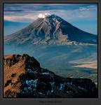
Just before 9 A.M. we arrived on the summit and were greeted with an incredible view. The sky was clear blue and the outlines of Pico de Orizaba and Iztaccihuatl stood sharp and impressive. In the valley's below the smog was already beginning to build as Mexico City came alive. Having looked into many craters over the years it still never fails to impressive me when I look down into another one. Below the craters virtually sheer walls was another smaller crater and inside that one was a small blue lake. Belching out of fissures on the crater wall steam and smoke periodically shot upwards and the strong smell of sulfur permeated our nostrils. Neither of us talked about being concerned if an unexpected eruption from the Aztec Warrior were to take place. We were just basking in the glory of being on the summit of such a beautiful mountain.

After nearly an hour on the summit we decided it was time to head back down to Tlamacas. We discussed the two descent routes, the Ventorillo and Las Cruces, and decided to walk around the crater and descend the easy Las Cruces. We knew that we could have quickly descended the route we climbed because it was such a direct route to the summit but with it being only mid morning we chose to explore the mountain. After circumventing the crater we dropped down on to the Las Cruces trail passing many climbers still on their way to the summit. Although the path was very gentle and easy we kept thinking that it would have been an unpleasant climb because of the loose scree and the extra distance the trail takes as it winds around the mountain. Several places we stopped to lay down and rest and take in the view but by 12:30 we were back at the hostel taking on badly needed fluids.

Over the years since I climbed the mountain I have continued to follow the story of Popocatepetl and its increasing volcanic action. This stratocone volcano is one of Mexico's most active volcanoes and more than thirty million people live within view of the volcano. Major eruptions about 5,000, 2,000 and 1,000 years ago produced widespread tephra fall, pyroclastic flows on all flanks of the volcano and lahars that buried villages.

In 1992 the mountain began showing an increase in seismic activity and a noticeable increase in fumarolic activity in the summit crater. Throughout 1995 and early 1996, Popocatepetl produced occasional phreatic explosions accompanied by intermittent low-magnitude seismicity and anomalously high emissions of Sulpher Dioxide. By the end of March, a new lava dome was identified in the summit crater indicating that a magmatic phase of the current eruptive episode had begun. Finally, on April 30, 1996, an explosion of the new dome killed five climbers who were at the summit and did not heed warnings that closed the volcano to climbers. They are the only casualties to date.

Over the next year occasional moderate eruptions sent columns of volcanic ash several kilometres into the air but on June 30, 1997, Popocatepetl threw ash twelve kilometres into the air during its largest eruption since 1925. The falling ash fell over Mexico City seventy-two kilometres away and caused the shut down of the international airport for fourteen hours.

Up until April 2003, Popocatepetl has continued to remain active. Pyroclastic flows have halted eight kilometers from the town of Santiago Xalitzintla and caused some melting of the summit glacier. Surrounding villages and towns such as Amecameca and Santiago Xalintzintla have been on high alert (Alert Level Yellow Phase III) and the road up to the Paseo de Cortés and the hotel at Tlamacas has been closed. Those wishing to climb the mountain have had to seek alternate destinations.


Volcanologists try to predict when the mountain will erupt using data collected over the years and from studying similar types of volcanoes, but ultimately the mountain has a mind of its own. Those living within reach of the outfall are willing to accept the risk as they have chosen to live within the shadow of the volcano. For mountaineers, the volcano will be continue to attract a certain breed of climber fascinated with the challenge of ascending the slopes to look into another summit crater and to play roulette with the forces of nature. When Popocatepetl vents its anger, maybe it is just the Aztec Warrior letting out a heavy sigh as he remembers the loss of his beloved Iztaccihuatl

October 12, 2009

Mount Etna


Standing at almost 11,000 feet, Mount Etna dominates the Sicilian skyline, a vague threat situated near the island"s eastern coast. This is the most active volcano in the world. The ancient Greeks believed it to be the home of Vulcan, the god of fire - to them, Mount Etna erupting merely meant Vulcan was forging weapons for Mars, the god of war. Dating back to 1500 BC, the volcano has erupted around 200 times, and the 21st century saw Mount Etna erupting yet again in 2001, with lava flows reaching within mere miles of the nearby town of Nicolosi. But regardless of the history of Mount Etna, the people that live within the volcano"s destructive reach seem completely unfazed.

A map of Mount Etna shows a swirling tangle of dried lava and colorful forests. Near the foot of the volcano, there are a multitude of vineyards and olive groves. As you climb higher, the lowlands evolve into dense woods sheltering a surprisingly large number of animal species that call the mountainside home, until you are left at the third tier of the mountain, a spartan wasteland of historic lava flows and volcanic ash. Dotted with snow most of the year, some of the lava is dated at 300,000 years old. In the past, scientists have used this area to test robots before they send them to Mars, becasue the atmospheric and geological conditions are so similar.

The most violent eruption in the history of Mount Etna occurred in March of 1669. On the first day, lava flows cut a smoldering gash out of two mountain villages. The volcano did not stop there, however. It continued to spew forth-molten rock for days on end, and by the end of April, the city walls of Catania had succumbed and the western side of the city was demolished before the lava mercifully came to a stop.

Despite the daily threat of Mount Etna erupting, tours into the unsteady heart of the volcano are readily available for the intrepid hiker. A map of Mount Etna will show that the south side is free for all to traverse, but you"ll need a guide if you want to make it to look directly into the eye of the great volcano. This hike is well worth it, though - it allows you to see, smell and touch the turbulent history of Mount Etna. Before any climb, it is imperative to check into the tourist office in Catania to learn the present status of the volcano, hiking instructions and to get a map of Mount Etna, detailing all the viewpoints of Sicily"s most explosive natural attraction.

the Maori cultures

Indigenous Culture

The Māori people are the indigenous people of Aotearoa (New Zealand) and first arrived here in waka hourua (voyaging canoes) from their ancestral homeland of Hawaiki over 1000 years ago. Today, Māori make up over 14 percent of the population. Their language and culture has a major impact on all facets of New Zealand life.
Rich and Varied

Māori culture is a rich and varied one, and includes traditional and contemporary arts. Traditional arts such as carving, weaving, kapa haka (group performance), whaikorero (oratory) and moko (tattoo) are practised throughout the country. Practitioners following in the footsteps of their tipuna (ancestors) replicate the techniques used hundreds of years ago, yet also develop exciting new techniques and forms. Today Māori culture also includes art, film, television, poetry, theatre, and hip-hop.
Stories and Legends

Māori is an oral culture rich with stories and legends. The Māori creation story describes the world being formed by the violent separation of Ranginui, the Sky Father, and Papatuanuku, the Earth Mother, by their children. Many Māori carvings and artworks graphically depict this struggle.
Fishing Up An Island

The creation of New Zealand is described by the legend of Maui. This god managed, among other things, to harness the sun in order to make the days longer. However, his biggest claim to fame was his fishing up of the North Island, which is described as Te Ika a Maui (the fish of Maui). A look at an aerial map of the North Island will show how closely it resembles a fish. Māori believe the far north to be the tail of the fish and Wellington Harbour the mouth. Māori describe the South Island as Maui’s waka (canoe) and Stewart Island (Rakiura) as his punga (anchor).


Te Reo Māori — the Māori Language

The visitor to New Zealand will become immediately aware of the Māori language as the vast majority of place names are of Māori origin. At first, visitors may be puzzled by the seemingly impossible- to-pronounce names. In fact, Māori has a logical structure, and, unlike English, has very consistent rules of pronunciation.
How Do You Say Onehunga, Whangamomona, Kahikatea, and Nguru?

Māori consists of five vowel sounds: a e i o u (‘a’ as in ‘car’, ‘e’ as in ‘egg’, ‘i’ like the ‘ee’ in ‘tee’, ‘o’ as in ‘four’, ‘u’ like an ‘o’ in ‘to’). There are eight consonants in Māori similar to those in English — ‘h’, ‘k’, ‘m’, ‘n’, ‘p’, ‘r’, ‘t’, and ‘w’. There are also two different consonants — ‘wh’ and ‘ng’. Many Māori pronounce the ‘wh’ sound similar to our ‘f’. The ‘ng’ is similar to our own ‘ng’ sound in a word like ‘sing’, except that in Māori, words can start with ‘ng’.
Kia ora = Gidday!

An attempt by a visitor to use Māori greetings will almost certainly elicit a delighted response from both Māori and Pakeha (European) New Zealanders.

Kia ora — Hello
Kia ora tatou — Hello everyone
Tena koe — Greetings to you (said to one person)
Tena koutou — Greeting to you all
Haere mai — Welcome
Nau mai — Welcome
Kei te pehea koe? — How’s it going?
Kei te pai — Good
Tino pai — Really good
Haere ra — Farewell
Ka kite ano — Until I see you again (Bye)
Hei konei ra — See you later


Video Feature
MAORI CULTURE
The Maori are the indigenous people of Aotearoa New Zealand, and have a rich and varied culture.
Open Movie

Māori Protocol

Being a tribal Polynesian people, Māori have a unique protocol. The best place to observe it is on a marae (Māori meeting grounds). Many tourist operators in New Zealand organise visits to marae.
Welcome to the Powhiri

A powhiri (formal welcome) at a marae begins with wero (challenge) A warrior from the tangata whenua (hosts) will challenge the manuhiri (guests). He may carry a spear (taiaha) then lay down a token (often a small branch) that the manuhiri will pick up to show they come in peace. Some kuia (women) from the tangata whenua (hosts) will perform a karanga (call/chant) to the manuhiri. Women from the manuhiri will then respond as they move onto the marae in front of their men.
Whaikorero — Speeches of Welcome

Once inside the wharenui (meeting house) on the marae, mihimihi (greetings) and whaikorero (speeches) are made. To reinforce the good wishes of the speeches, waiata (songs) may be sung. It is usual for the manuhiri then present a koha (gift) to the tangata whenua after greeting the hosts with a hongi — the ceremonial touching of noses. After the powhiri, kai (food) may be shared.

Interesting Places in Fiji

The Fiji islands, located in the South Pacific, are a popular tourist destination for people looking to relax on pristine beaches and take part in world-class scuba diving. The warmth of the Fijian Islanders is legendary, adding to this relaxed and beautiful tropical paradise.

Coral Coast
1. The Coral Coast, on the southern part of island of Viti Levu, offers miles of white beaches and crystal blue water perfect for swimming, relaxing and snorkeling.
Yasawas
2. The Yasawas are an archipelago of 20 islands that were closed to tourists until the 1980s. Turtle Island is one of the most popular resorts in the Fiji Islands.
Mamanucas
3. The Mamanucas are another set of islands popular for tourism. Some of these islands become completely covered by the ocean at high tide. This group is south of the Yasawas and features many resorts.
Nananu-I-Ra
4. This small island inhabited by mostly European retirees is a popular location for windsurfers. There are currently plans to develop more resorts on the island.
Suva
5. Suva is Fiji's largest city. It is where the Fijian government meets and is home to the Fiji Museum and many gardens and parks. Cumming Street, operational since colonial times, is a popular locale for shopping.

Easter Island


One of the world's most famous yet least visited archaeological sites, Easter Island is a small, hilly, now treeless island of volcanic origin. Located in the Pacific Ocean at 27 degrees south of the equator and some 2200 miles (3600 kilometers) off the coast of Chile, it is considered to be the world's most remote inhabited island. Sixty-three square miles in size and with three extinct volcanoes (the tallest rising to 1674 feet), the island is, technically speaking, a single massive volcano rising over ten thousand feet from the Pacific Ocean floor. The oldest known traditional name of the island is Te Pito o Te Henua, meaning ‘The Center (or Navel) of the World.’ In the 1860’s Tahitian sailors gave the island the name Rapa Nui, meaning ‘Great Rapa,’ due to its resemblance to another island in Polynesia called Rapa Iti, meaning ‘Little Rapa’. The island received its most well known current name from the Dutch sea captain Jacob Roggeveen, who, on Easter Sunday, April 5, 1722, became the first European to visit.

In the early 1950s, the Norwegian explorer Thor Heyerdahl (famous for his Kon-Tiki and Ra raft voyages across the oceans) popularized the idea that the island had been originally settled by advanced societies of Indians from the coast of South America. Extensive archaeological, ethnographic, and linguistic research has conclusively shown this hypothesis to be inaccurate. It is now recognized that the original inhabitants of Easter Island are of Polynesian stock (DNA extracts from skeletons have recently confirmed this), that they most probably came from the Marquesas or Society islands, and that they had arrived as early as 318 AD (carbon dating of reeds from a grave confirms this). At the time of their arrival, the island was entirely covered with thick forests, was teeming with land birds, and was the richest breeding site for seabirds in the Polynesia region. Within a matter of centuries this profusion of wildlife was destroyed by the islanders' way of life. The reasons are today eminently clear.

It is estimated that the original colonists, who may have been lost at sea, arrived in only a few canoes and numbered fewer than 100. Because of the plentiful bird, fish and plant food sources, the population grew rapidly and gave rise to a rich religious and artistic culture. However, the resource needs of the growing population inevitably outpaced the island's capacity to renew itself ecologically and the ensuing environmental degradation triggered a social and cultural collapse. Pollen records show that the destruction of the forests was well under way by the year 800, just a few centuries after the start of the first settlement. These forest trees were extremely important to the islanders, being used for fuel, for the construction of houses and ocean-fishing canoes, and as rollers for transporting the great stone statues. By the 1400s the forests had been entirely cut, the rich ground cover had eroded away, the springs had dried up, and the vast flocks of birds coming to roost on the island had long since disappeared. With no logs to build canoes for offshore fishing, with depleted bird and wildlife food sources, and with declining crop yields because of the erosion of good soil, the nutritional intake of the people plummeted. First famine, then cannibalism, set in. Because the island could no longer feed the chiefs, bureaucrats and priests who kept the complex society running, chaos resulted, and by 1700 the population dropped to between one-quarter and one-tenth of its former number. During the mid 1700s rival clans began to topple each other's stone statues. By 1864 the last of the statues was thrown down and desecrated.

Fact About Stonehenge


* Stonehenge was built between 3100 – 1100 BCE.
* The circle was aligned with the midsummer sunrise, the midwinter sunset, and the most southerly rising and northerly setting of the moon.
* The ground plan and structural engineering of Stonehenge incorporate sophisticated mathematical and geometrical understandings on the part of its builders.
* There were two types of stones used in its construction: the ‘bluestones’ (weighing as much as four tons and brought from 240 miles away) and the Sarsen stones (averaging eighteen feet in height and twenty-five tons in weight).
* It has been estimated that the construction of Stonehenge required more than thirty million hours of labor.
* More than nine hundred stone rings exist in the British Isles. Of these, Stonehenge is the most well known.
* The megalithic monuments of Britain and Europe predate those of the eastern Mediterranean, Egyptian, Mycenaean and Greek cultures.
* The Druids had nothing to do with the construction of the stone rings. Druids are known to have conducted their ritual activities mostly in sacred forest groves.

Stonehenge Purposes

* Prior to the 1950’s most archaeologists believed that Stonehenge’s use had been limited to the ritual activities of different Neolithic chiefdoms. However, it is now known that Stonehenge had another equally important function, which was its use as an astronomical observatory.
* In the 1950s and 1960s, the Oxford University engineer Professor Alexander Thom and the astronomer Gerald Hawkins pioneered the new field of archaeoastronomy - the study of the astronomies of ancient civilizations. Conducting surveys at Stonehenge and other megalithic structures, Thom and Hawkins discovered many significant astronomical alignments among the stones. This evidence indicates that Stonehenge and other stone rings were used as astronomical observatories.
* Stonehenge was simultaneously used for both astronomical observation and ritual function. By gathering data regarding the movement of celestial bodies, the Stonehenge observations were used to indicate appropriate periods in the annual ritual cycle. During those periods, among them being the solstices, equinoxes and different lunar days, festivals and ceremonies were held.

Stonehenge Legends

* Myths and legends of Stonehenge shed light on the nature of the activities and ceremonies performed at the festivals. For example, the legendary Merlin tells King Aurelius:

Laugh not so lightly, King, for not lightly are these words spoken. For in these stones is a mystery, and a healing virtue against many ailments. Giants of old did carry them from the furthest ends of Africa and did set them up in Ireland what time they did inhabit therein. And unto this end they did it, that they might make them baths therein whensoever they ailed of any malady, for they did wash the stones and pour forth the water into the baths, whereby they that were sick were made whole. Moreover they did mix confections of herbs with the water, whereby they that were wounded had healing, for not a stone is there that lacketh in virtue of leechcraft.
* And Layamon, a 13th century British poet, also speaks of the healing quality of Stonehenge.

The stones are great
And magic power they have
Men that are sick
Fare to that stone
And they wash that stone
And with that water bathe away their sickness

October 9, 2009

Sibiu the German Heritage


In the lands of legends, a certain city stands out nowadays, being the best preserved medieval settlement and a cultural reference for the whole region - Sibiu or Hermanstadt. Sibiu has been the center of the German minority since the medieval times and nowadays it is a major tourist attraction in Transylvania.


Sibiu is located about 300 kilometers away from Bucharest, but it has its own international airport, therefore it’s reachable by plane, car or train. The medieval charm, the amazing food, the surrounding landscapes (The Carpathians) and the friendly people made Sibiu one of the top destinations in Eastern Europe, in just two years after being nominated as the cultural capital of Europe.


The city center, also the historical center, is packed with attractions and museums, so you don’t need a car to explore this wonderful town. Walking or riding a bike will do fine. You can guide yourself using the Council Tower, an impressive structure erected in the 12th century and the tallest tower in town. If you choose to climb up in the tower through the dizzing stairs, you won’t regret the view.


Make sure you don’t miss the Brukenthal Museum and the Gallery of Arts, hosted in two buildings in the Main Square that used to be the home of the most famous baron that lived in Sibiu. Original pieces of furniture and crockery, as well as famous paintings of Romanian, Austrian, German and Italian painters are available in the museum.


Just steps away, in the Huet Square, you can admire the most impressive church in Sibiu. The Evangelic Church was raised in the 14th century and it has the tallest church tower in Transylvania (74 meters). It’s the only place in Sibiu where you can enjoy organ concerts, in the summer and on Wednesday nights.


Also, take some pictures on or underneath Sibiu’s landmark: the Liars Bridge. It’s Transylvania’s oldest cast iron bridge and no one knows for sure why the people named it this way. Some say that it’s the translation from the German lugenmarchen, which also means “lie”. Others say that the dishonest merchants were thrown off the bridge in the old times, but most of the people agree with the following theory: the bridge was a popular walking place for all lovers, especially for the military cadets and lots of promises were made there, most of them being lies.

Nova Scotia Genealogy

For centuries, Nova Scotia has been the gateway to Canada, and many Canadians can trace their family tree to here. From the arrival of the earliest explorers like John Cabot, to Samuel de Champlain’s band of hardy adventurers determined to settle an untamed world, to waves of Scottish immigrants and British soldiers, to German farmers from the Rhine Valley - Nova Scotia has welcomed them all.


Canadian’s Immigration History

With easy access to the Atlantic and one of the world’s largest natural harbours, there’s a reason why Nova Scotia has been the entrance to millions of Canadian immigrants – and is important to so many people while tracing their family trees. You can still see the immigration sheds of Pier 21 National Historic Site in Halifax where over a million immigrants, troops, war brides, and evacuee children started their new lives.

In Nova Scotia we also live our history. You can explore the colourful fishing town of Lunenburg, a UNESCO World Heritage Site, and still home to many hard-working fishermen today. Or you can relive a day in the life of 1744 at the Fortress of Louisbourg, the largest reconstruction of its kind in North America.

Trace your Nova Scotia genealogy at the Halifax Archives back to a quiet churchyard in a small town, or explore the living poetry of Acadia at the Grand Pre National Historic site. Make our history your own by:

Visiting the Alexander Graham Bell National Historic Site of Canada in Baddeck on Cape Breton Island, and discovering how he and his associates produced the fastest boat in the world, made improvements to the phonograph and, of course, invented the telephone.
Taking in the pageantry of Pipefest as part of the International Gathering of the Clans or visit communities that have hosted musical events for generations during the Celtic Colours International Festival.
Transporting yourself back to 1780 by joining in the encampment at Liverpool’s Privateer Days.
Experience the noon day cannon at Citadel Hill
Day trip or full immersion, a trip back in time is a vital part of many Nova Scotia vacations.

NOVA SCOTIA

Tour Canada’s Bay of Fundy

A billion tons of water moving in and out of Canada’s Bay of Fundy twice a day for eternity has created a remarkable and unique seascape between Nova Scotia and its neighbour, New Brunswick. The Bay of Fundy tide, the highest in the world; as high as a four-storey building, is five times higher than the Atlantic Coast average, gives rise to beachcombing for sparkling amethysts at low tide, to fascinating tours, and to fun-filled Tidal Bore rafting when the rising waters cover hundreds of meters of ground in only minutes.

Having caused steady erosion over millions of years, the tides historical impact on the terrain is evident. The waters have carved overhanging sea caves and cliffs, and low tide is a perfect time for fossil hunting. Nova Scotia vacations to the Bay of Fundy should include a stop at The Joggins Fossil Centre on the Fundy Shore, where you will find the world's largest collection of 300 million-year-old Joggins Fossils.

The nutrient-rich Bay of Fundy is home to some amazing marine life. The finback whale, the second largest animal on earth, comes to the Bay of Fundy to feed and play along with the Right whales, Minke whales and Humpbacks. A whale watching tour will give you a new definition for "awesome".

There are amazing experiences to be found along the Fundy Shore & Annapolis Valley that unwind along the land and sea of the Fundy shoreline. Visit the Cape d’Or lighthouse located on a panoramic point of land where the Minas Basin meets the Bay of Fundy, or simply spend an afternoon sunbathing on sands of Five Islands Park.

Tour the Ocean Floor

One of Canada’s ecological wonders, you can walk on the Bay of Fundy seabed at low tide, which only hours before held waters as high as a four-storey building. You can also hike to the trails of Cape Chignecto Provincial Park to see the Three Sisters, one of Nova Scotia’s most famous rock formations, accessible only by boat or trail. Kayak the waters of the Bay as you spy on the shorebirds and diverse marine life.

October 5, 2009


Climb to the top of Palatine Hill (Monte Palatino).
Legend has it that the ancient city of Rome was born atop Palatine Hill. Well-preserved samples of Roman era palaces and temples still stand, incorporated into the natural landscape by trees and vegetation that grow out of the ruins. Today these sites -- which include the Baths of Septimus Severus -- feel more like a park than an archeological site. Quiet paths shaded by slanting maritime pines give the place a serene feel. For a treat, visit Palatine Hill at early dusk, and watch the sun set on the center of ancient Rome -- from Circus Maximus, to the Forum, to the Colosseum.

Stroll the grounds of the Roman Forum (Foro Romano).
You won't have to strain your imagination to picture the Forum as the political, commercial and religious center that it once was, Columns, arches and temples built between 500 B.C. and A.D. 400 -- including the Temple of Vesta, where virgins once guarded the sacred fire -- are artifacts of its ancient prominence. This center fills the valley between Capitoline and Palatine hills.

Imagine yourself a gladiator at the Colosseum (Colosseo).
The Colosseum is the most recognizable symbol of Rome. Once called the Flavian Ampitheater, it was built from A.D. 72 to A.D. 80 -- in just eight years. Here, up to 50,000 spectators -- protected from the sun by an ingenious system of shades -- packed the stands to watch Roman gladiators fight it out in the ultimate combat. Today, the only wild animals haunting visitors are stray cats that make their home in the shadow of this monument.

Make a wish at Trevi Fountain (Fontana di Trevi).
Squashed into the corner of a small piazza, Trevi Fountain's statue of Neptune seems ready to burst forward from the ancient Acqua Vergine aqueduct. The recently cleaned, and gleaming, 18th-century fountain is one of Rome's most famous sights. It draws throngs of tourists, who crowd into the tiny square to toss coins into the water over their left shoulders; legend says this assures a return trip to the city.

Take a break on the Spanish Steps.
A grand outdoor staircase, the Spanish Steps offer a fabulous view of city monuments and rooftops. But they are also a great vantage point for people watching. The Spanish Steps are the meeting place in Rome, filled daily with guitar-playing city dwellers and stylish shoppers descending on the piazza's world-class boutiques. When you've had enough rest, head next door to the Keats-Shelley house, and take a look at memorabilia from literature's Romantic period. Or take a sip and a photo in front of the piazza's azalea-trimmed Fontana della Barcaccia (Old Boat Fountain).


Admire Rome's best-preserved monument, the Pantheon.
An architectural wonder in simplicity, this domed temple was built in 27 B.C. as a tribute to all gods and then rebuilt in the second century A.D. by Emperor Hadrian. It is one of Rome's best-preserved monuments, despite the removal of its marble walls, and bronze ceiling during the Renaissance. The round temple includes a series of columns topped by a dome, which boasts a 30-foot opening to let in light. It remains the burial site of the first ruler of the Kingdom of Italy, Victor Emmanuel II, and artist, Rafael.

Take an evening stroll at Holy Angel Castle (Castel Sant'Angelo).
The Castel Sant'Angelo's is a distinctive round building, nestled between the Tiber and the Vatican. It was built in A.D. 135 as Emperor Hadrian's mausoleum. Later it was used as a fortress and a prison, even providing an escape route for popes via the connected corridor running atop the wall encircling the Vatican. Inside, the castle not only serves up fabulous views of the city, but also houses medieval cells, frescoed halls and a museum of arms and armor. And if you want to experience the romance of Rome, you can't beat a stroll across the Ponte Sant'Angelo at night. Newly installed floodlights dramatically illuminate the 10 angel statues flanking this approach to the castle.


Visit St. Peter's Square and Basilica (Basilica di San Pietro).
As the largest church in the world, St. Peter's Basilica features stunning architecture, works of art and a chance to see the pope, who addresses the public in the square on Wednesdays and Sundays when he is in town. Inside, the bronze statue of St. Peter draws crowds, as does Michelangelo's 1499 depiction of the Pieta. And ascending St. Peter's 435-foot dome provides a great vantage point for viewing the city and the pope's gardens. But not to be missed is the ancient necropolis, or "city of the dead," beneath the basilica. Plan ahead, because the small tours of St. Peter's scavi (excavation) require reservations through the Vatican offices. St. Peter's bones are believed to be buried there; the burial site is preserved, along with the Constantinian-era basilica and Nero's Circus.

Visit the Vatican Museums, and see the Sistine Chapel (Cappella Sistina).
A journey through the 4.5 miles of displays in the Vatican Museums begins at the foot of an impressive double helix stairwell. Because it is one of the largest collections in the world, seeing all of the Vatican Museums is a near-impossible task for the casual tourist. But no matter how short your time, you don't want to miss the frescoed ceiling of the Sistine Chapel, or Michelangelo's Last Judgement fresco behind the chapel altar. The museum also is home to artworks of every age, from early Egypt to the present day.


Walk along the Ancient Appian Way (Via Appia Antica), and visit the catacombs.
The Appian Way, or "queen of roads," was the first and most important of the Roman Empire's great roads. Built entirely from cobblestone in 213 B.C., today it is scattered with ancient monuments and, most notably, a series of catacombs. These burial sites are underground labyrinths dug out of volcanic rock, outside the city walls due to laws forbidding burial in ancient Rome. Be sure to visit the Catacombe di San Callisto, one of the oldest and best-preserved, and the Catacombe di San Sebastiano. Unlike most catacombs, San Sebastiano also contains pagan tombs. But it once housed the remains of St. Peter and St. Paul, and its basilica still contains the basalt Domino Quo Vadis footprint, made, according to tradition, by the foot of Jesus Christ. .

October 2, 2009

trains in Korea....


The KTX (short for Korea Train eXpress) is easily the fastest - but most expensive - way to travel by train. Offering a trip from Seoul to Busan in just under three hours at a top speed of 300 kph, you're paying for speed and convenience to major destinations. KTX trains make fewer stops, but run more trains to the major destinations than the other classes of trains. A new high-speed line is currently under construction in southern South Korea; when completed at the end of 2010, it will reduce the Seoul-Busan trip time to approximately 2 hours and 10 minutes. (Source: Wikipedia)

The Saemaeul-class (새마을) trains can be considered Korea's second-class trains. Until recently, this was the fastest way to get from point A to point B, and still maintains a good balance between speed and number of stops. The name 'Saemaeul' comes from the Saemaeul Undong, a movement in the 1970's to make rural South Korea more modern.

The Muganghwa-class (무궁화) trains can be considered Korea's third-class trains. Although these trains make more stops than the other two classes of trains combined, the train's comfort and cost of tickets may actually make this the preferred mode of transportation for some. While these trains will take the longest, these are the only trains that stop at some train stations. The name 'Muganghwa' comes the national flower of South Korea of the same name.

The Tonggeun (통근) or 'commuter-class' trains only run a couple specific routes. These trains will make many stops during their runs, and only serve smaller or more rural communities that have a train connection. The few lines that still use Tonggeun-class trains primarily run to the northern Gyeonggi-do areas, including the Gyeongwon Line (Dongducheon-Sintan-ri) and the Gyeongui Line (Munsan-Dorasan). Don't confuse this with the subway line of the same name - that line terminates at Munsan. To go any farther north you'll need to hop on the Tonggeun train.
The Nooriro-class (누리로) is a new class of trains that compromises between the Muganghwa-class train and the comparatively slower Seoul subway. While it runs on the same line as line 1 of the subway system, it makes fewer stops than the subway does (stops include Yeungdeungpo, Anyang, Suwon, Pyeongtaek, Cheonan, Asan, Onyang Oncheon, and Sinchang). While you pay the same for the Muganghwa-class train, you get there a little faster. This class of service is expected to replace the now-aging Mugunghwa trains, but they don't yet seem to have a lot of demand.

Famous examples of Islamic Architecture


During the Islamic civilization, around 10th century, the activity of exploring pattern and symmetry truly blossomed. For a period of about 400 years there was vigorous creativity. This resulted in a large number of sophisticated geometrical patterns and two of the most sublime monuments to symmetry that have ever been built- namely, the Nasrid Palace of Alhambra in Granada in Spain and the Taj Mahal in Agra in India.

The Alhambra is a walled city and fortress in Granada, Spain. It was built during the last Islamic sultanate on the Iberian peninsula, the Nasrid Dynasty (1238-1492). The palace is lavishly decorated with stone and wood carvings and tile patterns on most of the ceilings, walls, and floors. Islamic art does not use representations of living beings, but heavily uses geometric patterns, especially symmetric (repeating) patterns.

As for the Taj Mahal, Western historians have noted that its architectural beauty has never been surpassed. The Taj is the most beautiful monument built by the Mughals, the Muslim rulers of India. It was built by a Muslim, Emperor Shah Jahan (died 1666 C.E.) in the memory of his dear wife and queen Mumtaz Mahal. Taj Mahal (meaning Crown Palace) is a Mausoleum that houses the grave of queen Mumtaz Mahal at the lower chamber. It is built entirely of white marble. Its stunning architectural beauty is beyond adequate description, particularly at dawn and sunset. The Taj seems to glow in the light of the full moon. It is an "elegy in marble" or some say an expression of a "dream."

famous building in Moscow


Saint Basil´s Cathedral is traditionally perceived as symbolic of the unique position of Russia between Europe and Asia. The cathedral was commissioned by Ivan the Terrible and built between 1555 and 1561 in Moscow to commemorate the capture of the Khanate of Kazan. Saint Basil´s is located at the southeast end of Red Square, just across from the Spasskaya Tower of the Kremlin. Not particularly large, it consists of nine chapels built on a single foundation. The initial concept was to build a cluster of chapels, one dedicated to each of the saints on whose feast day the tsar had won a battle, but the construction of a single central tower unifies these spaces into a single cathedral. A popular but untrue legend says that Ivan had the architect, Postnik Yakovlev, blinded to prevent him from building a more magnificent building for anyone else.