Pages

Showing posts with label geography in tourism. Show all posts

December 23, 2010

'K' Stands for Kundasang ! Part II

Okay, so another post about 'K'. Well the next day of the trip which on Dec 19th, 2010....hm ~ nothing much happen. It's 7.05am and Gerard cell phone started to ring out loud makes me want to crash it with my cold bare hand( but no, to lazy for that of course...early in the morning I supposed) when I look out the window, Mala and Esther has already wake up from their bed and I heard something from them but not really clear....oh well whatever ~~


I straightly went to the bathroom to have my morning shower and the water at first was really COLD like ICE!! BRRRrrrr....Then suddenly the water turns out became really hot and I was really shock. As if I was bathing in hot boiled water. God this really killing me. I don't care and no choice but just straightly had to continue bathing. The bathroom situated in front of the Livingroom and when I went out lucky for me there was only my sister watching her favourite T.V show and perhaps just ignore me. I just smiled silently....(crazy...)


Later I found out that our friend Mr John Chin actually in early morning he was knocking each and everyones room with an intention to invite us go for a jog around the area...okay. FYR, the place that we stay ws really like ....maybe 20 minutes away from another stay-in or villa by car.... Well I'm to damn tired all those trip on the previous day.
Maybe next time...


Here's the map

I don't don't really exactly know about the entire area was but I'm pretty sure it was like this ...( pretty ugly huh..) Oh well looks like he had to do it alone I guest. Then my friend Esther, calling us for breakfast from the next door. But unfortunately not everyone was ready so I and my twins go with her to the Villa's main cafeteria and sat down searching for the waiter or waitress. American breakfast anyone? Just what I need to strengthen my weak energy ( ...the taste of sausage kinda like " off Beat"?)


Everyone was looks very tired during those hour and sleepy too! How I wish I had a camera so I can capture every funny moment when we were there. Since we had to pay for the transportation, we had to prepared some expenses so the bus driver would take us all back to K.K ( our home sweet home). Since it was going to rain that day, Mr J.C said that he had to cancelled our trip to Kinabalu National Park and when I heard that I was quite sad though because this were my first trip to Kundasang and I don't get the chance to visit some places that I want to go. That's okay but still dissapointed...


Mr J.C might trying to cheer everyone but stopping by at the edge of high hill 30 minutes from the villa's. Funny thing when we made it at the hill everyone was taking picture together and leave Mr J.C behind ....hahaha poor him ~
10 minutes break and we finally take off to K.K, right where we belong!!

Trivia
- At first, everyone felt that this trip might not as good as the previous trip
- On our way to Kundasang, we came accross to accident where one which a car overturned and a truck that skidded off street, everyone was suprised but not the bus driver
- At poring, I saw a boy peeing in a pool which I think and feel bad for all the tourist who went inside the same pool
- That night, our dinner was chicken barbeque marinated with chicken sauce and such but funny things are...the taste seem a little bit sour!! Everyone thought it was the 'chef' fault but actually it's not
- Mr J.C saw a wooden insect which makes  me screamed  out  loud and  was   really shock! Well he teach me and   Gary Ting on how to get closer with the nature but Ting VS me, congratulation Gary Ting, you've won ( I run..)
- Same time at night, everyone was trilled with happy hour I supposed but we played the game called 'Truth or dare' turned out it was not really that fun at all
- Next visit to the hill, when everyone was ready for photo shoot with beautiful view at our back, later afterwards. the  very  strong wind and  misty  mist coming out from nowhere suddenly cover the view which makes everyone gone mad!! Mr J.c don't know what to do...

And yes, that's the end of the trip ~ Well pretty exciting huh?

November 24, 2010

Kudat Field Trip Part IV


 Our destination at the most beautifull place ever in Sabah....Welcome to The Tips of Borneo Everyone!!

On our way to the famous landmarks at the Tips of Borneo....WHOOSH!!


Look at the sea....AH ~~ the breeze....so calm and relax


The view really are beautifull...

Blue sky and gentle wave...


Beautifull people and friends...always with you no matter who you are...


Yup,that's me!!
This is our last destination for the trip...really enjoying every moment of it.....

November 15, 2010

Kudat Field Trips Part II

Hello everyone, I'm just back from Kudat.
Ahhh...what an experiences I had way back from that place....tired yet so many sweet and great memories I'd gain from the trip fields and it's all with my fellow classmate. Cheers to all memories!

Okay on the way to our first destination, well you know how everybody was really excited about it.... some of my classmate even bought a guitar and play it along the journey. Well actually I never thought she was good in playing the guitar. Yup SHE. Who can resist good music from your friends and fall asleep? The journey to our firt destination takes about 2 hour from Kota Kinabalu. Thats a really long journey you know. As far as I remember, there's like three bus for this trip and of course DTM and DHM must stick together, right?

Okay back to topics, first destination was the Gombizou Honeybee Farm located in Matunggong, Kudat. You can read about this place in Sabah Tourism webpage. Sorry no picture for but I promise I'll include some picture later. We've some research by interviewing the people who manage the honeybee farm...the thing makes me itchy about this place was all the bees surrounding the lady who demonstrate about the honey-making...Ha I shoot some picture and run away from that place. Same goes to my sister too, we really hate bugs and all that stuff since we're little kid.
There's also honey that already been process and sold around....I think the big bottle was RM100, medium sized bottle was RM32 and the small one was RM14. After the honeybee, we went to the house where they present us their traditional dance called "Mogigol dance". And guest what I got the chance dancing with them. Although its a little embarassing, but hey let just think this way, the next time go there you won't be to dance with them because all the dancer ...in their golden age. So its worth it.

Next, we went to our second destination which are the great Gong Makaing Factory which was the place for the Rungus people makes it muscial instrument which played durinf festivities and even weddings. According to the villagers, the place has been part of World Record which I think really amazing. Such a cultural and tradition that still exist till today and still continuing the great living tradition from the past.
This place located not far from the Gombizou Honeybee Farm where it only takes about 5 minutes from there.Before we leave, they present us with 2 traditional dances which are the " Manaradan" and "Mogigol" at the Sumangkap Village community Hall. Same with the previous one but just a bit different actually. Then we went to another house where Ms Rohana demonstrate on how to make the gong. She brief us all about 15 minutes on how to measure the surface before you actually can knock it, how many inches for the center ( its 3 inches for sure..). She said that it takes about 3 days to get the goong-making done. So its kinda a lot of work you know. All the goong are label acccording to numbers. We also went to the biggest goong (20 feet high) and its was really awsome.
We take a lot of picture with friends plus the goong itself. So great that the big goong will never fall down when there's strong wind blowing it.( except for apocolypse I think) Fun moment!

Next destination, we went to the Bavanggazoo(Rungus Longhouse), a very long house made of natural material such as bamboo and some straw. Funny things happen here, when we first arrive at the place we found the right longhouse, but somebody I don't know who,Shout from the back of our group and told us we get the wrong longhouse, we supposed to climb the hill 10 minutes away from that place to get to the right place. So we all climb the hill but I run.... You should look at my face....tired but fun too.
At the longhouse, I take some picture of the Rungus people selling some cultural bracelet and stuff. GORGEOUS
The door if you pay a visit to the place, you'll notice that the doors or the rooms names are labels according to birds name. I was attracted to this traditional puzzle for the Rungus but I don't even remember the name the people told that once this game was take serious for the women ONLY in the village where if they cannot solve the puzzle, they won't be able to get married. Hmmm....interesting. But my future doesn't depend on that thing for god sake!
And yes, they present with similar dance and some my friends are dancing too but one thing for sure attract when the old lady present a song by playing the flutes using her nose. Yes, her NOSE!!! She played graceful and delicated. I was like amaze by that, well some my friend are asleep (silly pig... ).
We can't get to Tamu Kudatbecause we're running out off time. Ngeh...

Next stop, Our resting place...its not some fancy hotel or something but good enough for us to sleep in. This what people said " back to basic" hehehehe . Okay I was group with my sister and two friends ( Micheal L. and Marilyn K.)which I think really great because their really nice people. 3 hour rest fine with me but I don't know the other including my sister. We then at 7.30p.m played a game ( passing puzzle )which was so....okay so lame but quite fun if you played with all total 70 plus of student in one night!
There few student incharge in this game where a cup of glass full of water was passing around in a circle of student with some music playing. And if the music stop or the water from the glass splash when you trying passing it, you'll get some punishment that totally embarrasing you. Ha ~~ I've once get the punishment by shuffling in front of everybody. But not for this trip! No way!
Funny thing was there's a girl were been punish by counting all the star and you know what she kept counting it. Hello ~~ just say crazy things like its has 8 billion star or something but she kept counting, counting and counting. Good luck with that! I'm really hungry at the time so I was just going with the flow.

After activity has ended, some student went into their room and some stil hanging around or having late night snack or something. Micheal went to dinner with Ah Tee and Vincent and my sister are just went straight back to our room. As for me, I went to department store with my friend Marilyn K. I bought food some cup instant noodles for me and my sister and for the dessert, just cocoa pie are enough good enough for your hungry little tummy!
Same goes to Marilyn K.
15 minutes after we came back to our room, we eat and done some talk in our room. Girls talk! Then Micheal and the boys went to the room which makes me quite suprised! Dull moment arose so us girl put make up to those 2 boys. Well the boys look so funny when their in make up especially Vincent whose face really looks like a girl!! All I can says was he's face looks pretty ugly but cute.
Surely I had lot of fun that night....in a good way of course!
It was fun and tiring, so I slept early eventhought I actually can't sleep over there....


To be Continue in Part III

July 30, 2010

Presentation...( science and mystery....hey thats a great combo)

last weak I was having my presentation about The underwater River in Mexico
Well I'm not an expert in diving but I'm really attracted to this fact whereby theres a river under the sea ....I was really fascunated with the name so I try to do some research about it..
Located in Cenote Angelita...this so - called 'river' was actually a river of Hydrogen Sulphide, H2S which are the colorless gas that rise from biological activity plus this kind of gas are featured in volcanic activity and natural gas. This place to me it still look mysterious yet amazing for some professional divers( allocentric) but not for those who are psychocentric ..=)

January 31, 2010

Table Mountain - South African jewel, international tourism icon and Natural World Heritage Site.

Situated at the south-western tip of Africa, the Table Mountain National Park (TMNP) encompasses the incredibly scenic Table Mountain Chain stretching from Signal Hill in the north to Cape Point in the south and the seas and coastline of the peninsula.

The narrow finger of land with its beautiful valleys, bays and beaches is surrounded by the waters of the Atlantic Ocean in the west and the warmer waters of False Bay and has within its boundaries two world-renowned landmarks - majestic Table Mountain and the legendary Cape of Good Hope.

The Park is recognised globally for its extraordinarily rich, diverse and unique fauna and flora - with rugged cliffs, steep slopes and sandy flats - is a truly remarkable natural, scenic, historical, cultural and recreational asset both locally and internationally. Nowhere else in the world does an area of such spectacular beauty and such rich bio-diversity exist almost entirely within a metropolitan area - the thriving and cosmopolitan city of Cape Town.

October 14, 2009

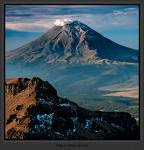
POPOCATEPETL MOUNTAIN


All these peaks are of volcanic origin, however, of these five peaks it is only Popocatepetl that is active and it is the volcanic activity that has brought about its climbing history. Before the arrival of the Spanish conquistadors, the Aztec emperor Moctezuma sent ten of his strongest warriors up the mountain to find the source of the smoke. Two of them died on the ascent while the rest reached the summit and saw the smoke belching from fissures within the crater. On the descent, another six perished from the cold, however, two managed to report what they had seen to Moctezuma but never recovered their pre-summit health.

The first European ascent of Popocatepetl happened in 1522 and marks the highest summit climbed by Europeans up to that time. The Spanish conqueror, Hernando Cortés, on his trek through Mexico, crossed the pass (Paseo de Cortés) between Popocatepetl and Iztaccihuatl and saw the Aztec capital of Tenochtitlán located where modern Mexico City is now situated. After his brutal conquest of the Aztecs, Cortés found himself in need of sulfur to replenish his supply of gunpowder. He dispatched a party of soldiers led by Francisco Montaño to climb Popocatepetl and obtain the material from the crater. They found the ascent trying due to the cold, temperatures they were not use too in the lower altitudes, but managed to reach the top. To acquire the sulfur, Montaño had to be lowered on a rope down the cliffs surrounding the crater. Despite his fears of falling and going straight to hell, he and his men managed to get hold of a supply of the badly needed yellow powder and return alive.

To the Aztecs, Popocatepetl is revered as one of the most important of their sacred mountains. Its rich volcanic soil combined with a congenial climate and plentiful water to make its lower slopes one of the most fertile and heavily populated areas of Pre-Columbian Mexico. The closer the maize grew to the mountain, the earlier it ripened and the better it tasted. Despite the mountains wrathful nature it represented to many Aztecs divine embodiment of all that was good and desirable.

The irony is that Cortés used a substance from the Aztec's sacred mountain to make gunpowder for killing people for the greater glory of the Spanish empire. At the same time the Aztecs performed their own bloodthirsty human sacrifices as a worship to the mountain.

In Nahuatl, the ancient language of the Aztecs, Popocatepetl means "smoking mountain" while neighbouring Iztaccihuatl means "sleeping woman." The close physical proximity of these two mountains has brought about a popular legend.

According to the widely held legend, Popocatepetl was a warrior of an Aztec tribe who fell in love with Iztaccihuatl, the daughter of the tribal chief. When the two lovers went to her father to ask to be allowed to marry, he told them he would only agree to their marriage if Popocatepetl would first conquer an enemy tribe and bring him the head of its leader. The young warrior succeeded in his mission, but he took so long that Iztaccihuatl, thinking he had perished, succumbed to sorrow. When Popocatepetl eventually returned triumphant, he found Iztaccihuatl dead, so he picked her up and carried her to the top of a mountain. He laid her along the summit ridge where she assumes the form of a sleeping woman - the shape many people see in the outline of Iztaccihuatl today. Popocatepetl lit a torch and stood watch over his lover, which accounts for the smoke that issues from the mountain that bears his name.

The ascents of Popocatepetl by Moctezuma's soldiers and Francisco Montaño were not considered, at the time, mountaineering feats, however, mountaineering as a sport took on a new meaning in the mid 1800's with the ascent of all the big peaks in the European Alps. Eventually, mountaineers began going abroad seeking new adventures. Mountaineers such as Edward Whymper, Matthias Zurbriggen and Edward Fitzgerald visited the mountains of New Zealand, Canada, South America and Mexico making their mark with first ascents of many previously unclimbed mountains. In the mid 1900's, with the convenience of cheap air travel and the advent of modern climbing techniques and equipment, contemporary mountaineers sought out the challenges of not only the lofty Himalayas, but also many exotic mountains including the Mexican volcanoes. These volcanoes have since become a popular destination, especially for North American's, seeking their first taste of high altitude mountaineering.


Technically there is nothing difficult about climbing Popocatepetl and many people have reached its summit including the Argentine revolutionary Ernesto (Che) Guevara. Guevara made an attempt in July with some of his Cuban friends but returned and summited on October 12, 1955. For Guevara, who suffered severely from asthma, the climb, which to him meant the summit, was the ultimate challenge. It was to prove his strength of mind and determination. As a revolutionary, and a climber, Guevara had the "to the summit or bust" attitude that we see in a few strong-minded Himalayan mountaineers. For them the goal must be achieved. Death is a natural consequence that they are willing to accept as we can see in Che's writing in a letter to his mother on July 20, 1955:


I took the Popo by assault, but despite much heroism, I was unable to reach the top. I was ready to die for it, but my Cuban climbing companion scared me because two of his toes froze… We spent six hours fighting the snow that buried us to our waist, and with feet totally drenched since we lacked the proper equipment. The guide got lost in the fog skirting a crevass, and we were exhausted from the soft and unending snow. The Cubans won't climb again, but for me, as soon as I have some money, I will challenge the Popo again ...

In 1988 it was my turn to make an ascent of the famous volcano. On the morning of October 19, Geoff Mahan and I left our hotel in Mexico City and took a bus to the small town of Amecameca. After picking up a few last minute supplies at the local supermarket we then arranged for a taxi to take the two of us up to the hotel at Tlamacas. Tlamacas being a popular destination not only for climbers but also for Mexican tourists to see the volcano up close and to take short hikes on the lower slopes. Once at the hotel we enquired about the condition of the huts higher up on the mountain and found there was no water available. Since we didn't have containers for carrying any extra water we decided to take a bunk in the climbers hostel adjacent to the hotel.

Although Geoff and I had spent four months climbing throughout the Andes of South America we found that in the last month of traveling in Central America we had lost much of our acclimatization. That afternoon we went for a walk up the trail to about 4,500 metres to familiarize ourselves with the route as we would be leaving the hostel in the early hours of the next morning for the summit. That evening we cooked our dinner outside and stared up at the mountain with the usual excitement before a climb.

At 3 A.M. our alarms went off. We had not really slept due to the altitude and our excitement but we were well rested. A light breakfast, a hot drink and by 3:50 our packs were on our shoulders and with the aid of our headlamps we began hiking up the trail of the Ventorillo Route. It felt good to be back in the mountains climbing a peak that we had read and dreamt about for many years. As we steadily gained altitude the dawning sun caressed the eastern slope of the mountain while to the west a huge shadow in the shape of the volcano materialized over the surrounding plains. At 4,630m we passed the Quentano Hut and then at 4,900 we arrived at the Ventorillo Hut. It had taken us three hours to reach the hut so we stopped for a short break. Not far beyond the hut we decided it was time to take off our running shoes. Climbing the scree trail was less tiring in our running shoes but now that we had arrived at the frozen snow it was time to put on climbing boots and crampons. Snow conditions were perfect as we gradually made our way up the thirty-five degree slopes towards the summit.


Just before 9 A.M. we arrived on the summit and were greeted with an incredible view. The sky was clear blue and the outlines of Pico de Orizaba and Iztaccihuatl stood sharp and impressive. In the valley's below the smog was already beginning to build as Mexico City came alive. Having looked into many craters over the years it still never fails to impressive me when I look down into another one. Below the craters virtually sheer walls was another smaller crater and inside that one was a small blue lake. Belching out of fissures on the crater wall steam and smoke periodically shot upwards and the strong smell of sulfur permeated our nostrils. Neither of us talked about being concerned if an unexpected eruption from the Aztec Warrior were to take place. We were just basking in the glory of being on the summit of such a beautiful mountain.

After nearly an hour on the summit we decided it was time to head back down to Tlamacas. We discussed the two descent routes, the Ventorillo and Las Cruces, and decided to walk around the crater and descend the easy Las Cruces. We knew that we could have quickly descended the route we climbed because it was such a direct route to the summit but with it being only mid morning we chose to explore the mountain. After circumventing the crater we dropped down on to the Las Cruces trail passing many climbers still on their way to the summit. Although the path was very gentle and easy we kept thinking that it would have been an unpleasant climb because of the loose scree and the extra distance the trail takes as it winds around the mountain. Several places we stopped to lay down and rest and take in the view but by 12:30 we were back at the hostel taking on badly needed fluids.

Over the years since I climbed the mountain I have continued to follow the story of Popocatepetl and its increasing volcanic action. This stratocone volcano is one of Mexico's most active volcanoes and more than thirty million people live within view of the volcano. Major eruptions about 5,000, 2,000 and 1,000 years ago produced widespread tephra fall, pyroclastic flows on all flanks of the volcano and lahars that buried villages.

In 1992 the mountain began showing an increase in seismic activity and a noticeable increase in fumarolic activity in the summit crater. Throughout 1995 and early 1996, Popocatepetl produced occasional phreatic explosions accompanied by intermittent low-magnitude seismicity and anomalously high emissions of Sulpher Dioxide. By the end of March, a new lava dome was identified in the summit crater indicating that a magmatic phase of the current eruptive episode had begun. Finally, on April 30, 1996, an explosion of the new dome killed five climbers who were at the summit and did not heed warnings that closed the volcano to climbers. They are the only casualties to date.

Over the next year occasional moderate eruptions sent columns of volcanic ash several kilometres into the air but on June 30, 1997, Popocatepetl threw ash twelve kilometres into the air during its largest eruption since 1925. The falling ash fell over Mexico City seventy-two kilometres away and caused the shut down of the international airport for fourteen hours.

Up until April 2003, Popocatepetl has continued to remain active. Pyroclastic flows have halted eight kilometers from the town of Santiago Xalitzintla and caused some melting of the summit glacier. Surrounding villages and towns such as Amecameca and Santiago Xalintzintla have been on high alert (Alert Level Yellow Phase III) and the road up to the Paseo de Cortés and the hotel at Tlamacas has been closed. Those wishing to climb the mountain have had to seek alternate destinations.


Volcanologists try to predict when the mountain will erupt using data collected over the years and from studying similar types of volcanoes, but ultimately the mountain has a mind of its own. Those living within reach of the outfall are willing to accept the risk as they have chosen to live within the shadow of the volcano. For mountaineers, the volcano will be continue to attract a certain breed of climber fascinated with the challenge of ascending the slopes to look into another summit crater and to play roulette with the forces of nature. When Popocatepetl vents its anger, maybe it is just the Aztec Warrior letting out a heavy sigh as he remembers the loss of his beloved Iztaccihuatl

October 12, 2009

Mount Etna


Standing at almost 11,000 feet, Mount Etna dominates the Sicilian skyline, a vague threat situated near the island"s eastern coast. This is the most active volcano in the world. The ancient Greeks believed it to be the home of Vulcan, the god of fire - to them, Mount Etna erupting merely meant Vulcan was forging weapons for Mars, the god of war. Dating back to 1500 BC, the volcano has erupted around 200 times, and the 21st century saw Mount Etna erupting yet again in 2001, with lava flows reaching within mere miles of the nearby town of Nicolosi. But regardless of the history of Mount Etna, the people that live within the volcano"s destructive reach seem completely unfazed.

A map of Mount Etna shows a swirling tangle of dried lava and colorful forests. Near the foot of the volcano, there are a multitude of vineyards and olive groves. As you climb higher, the lowlands evolve into dense woods sheltering a surprisingly large number of animal species that call the mountainside home, until you are left at the third tier of the mountain, a spartan wasteland of historic lava flows and volcanic ash. Dotted with snow most of the year, some of the lava is dated at 300,000 years old. In the past, scientists have used this area to test robots before they send them to Mars, becasue the atmospheric and geological conditions are so similar.

The most violent eruption in the history of Mount Etna occurred in March of 1669. On the first day, lava flows cut a smoldering gash out of two mountain villages. The volcano did not stop there, however. It continued to spew forth-molten rock for days on end, and by the end of April, the city walls of Catania had succumbed and the western side of the city was demolished before the lava mercifully came to a stop.

Despite the daily threat of Mount Etna erupting, tours into the unsteady heart of the volcano are readily available for the intrepid hiker. A map of Mount Etna will show that the south side is free for all to traverse, but you"ll need a guide if you want to make it to look directly into the eye of the great volcano. This hike is well worth it, though - it allows you to see, smell and touch the turbulent history of Mount Etna. Before any climb, it is imperative to check into the tourist office in Catania to learn the present status of the volcano, hiking instructions and to get a map of Mount Etna, detailing all the viewpoints of Sicily"s most explosive natural attraction.